
Last Updated on April 17, 2026
Guayabo National Monument: What's Covered
Guayabo National Monument is Costa Rica’s most significant pre-Columbian archaeological site—a 576-acre protected area near Turrialba containing the remains of a city occupied from roughly 1000 BCE to 1400 CE. Entry is $5 for foreigners, the site opens daily from 8 AM to 3:30 PM, and it’s about 52 miles (84 km) from San José—a manageable Central Valley day trip in a standard rental car.
Quick Facts:
- Location: 10.6 miles (17 km) from Turrialba, ~2 hours from San José
- Entry: $5 USD for foreigners (2024–2025)
- Hours: Daily 8 AM–3:30 PM, including holidays
- Vehicle: Standard sedan works fine — mostly paved roads
Top 4 Things to See:
- Aqueducts — Still flowing after 1,000 years; ASCE Historic Civil Engineering Landmark
- Stone mounds — Circular foundations from wooden homes; the tallest was the chief’s
- Causeways — Paved stone roads stretching up to 5.6 miles (9 km)
- Jaguar-crocodile petroglyph — Carved boulder with an unsolved mystery on both sides
Pairs well with Turrialba Volcano, Irazú Volcano, and Pacuare rafting. Dry season brings clearer skies; green season offers lusher forest and fewer visitors.
If you need any help with a Costa Rica car rental, contact us now!
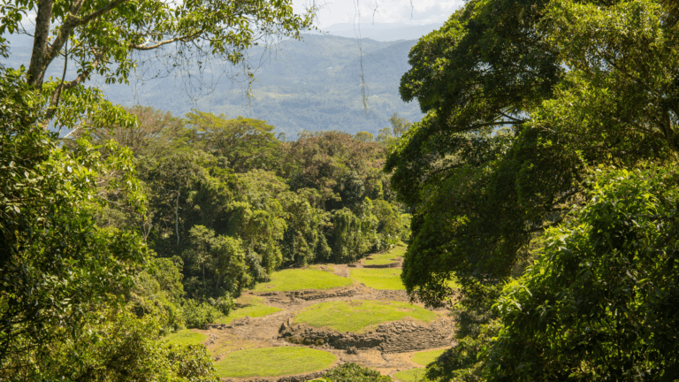
Costa Rica’s only significant archaeological site sits in the mist-covered highlands above Turrialba, where stone aqueducts still carry water after 1,000 years and circular foundations mark where a city of up to 10,000 people once stood—then vanished without a trace. Guayabo National Monument protects 576 acres (233 hectares) of premontane rainforest and the excavated remains of a pre-Columbian settlement occupied from roughly 1000 BCE to 1400 CE. The American Society of Civil Engineers named it a Historic Civil Engineering Landmark in 2009—the same designation held by the Hoover Dam and the Panama Canal.
This isn’t Machu Picchu. The scale is smaller, the structures more subtle, and the mystery considerably deeper. Only about 10% of the site has been excavated, which means nearly everything researchers know about who lived here remains educated guesswork. That ambiguity is actually what makes Guayabo fascinating—especially for travelers doing Central Valley day trips who want something more than another volcano viewpoint. For anyone building a Costa Rica itinerary around the Central Valley, Guayabo belongs on the list.
Key Takeaways
- Location: 10.6 miles (17 km) from Turrialba, approximately 52 miles (84 km) from San José
- Entry fee: $5 USD for foreigners (confirmed 2024–2025)
- Hours: Daily 8 AM–3:30 PM, including holidays
- Time needed: 1–2 hours for the ruins; add 1 hour for the nature trail
- Guide: Strongly recommended—the context transforms what you’re looking at
- Vehicle: Standard sedan works fine; roads are mostly paved
- Best combined with: Turrialba Volcano, Pacuare River rafting, or Irazú Volcano

What Is Guayabo National Monument, Exactly?
Guayabo is Costa Rica’s most important pre-Columbian archaeological site—the only one of significant scale in the country. The city was inhabited for roughly 2,400 years before its residents abandoned it around 1400 CE, about a century before Spanish explorers arrived. Unlike the monumental pyramids of Mexico or Guatemala, Guayabo’s structures are understated: circular stone foundations for wooden houses, interlocking aqueduct systems that still flow today, and stone-paved causeways that once connected this settlement to communities up to 5.6 miles (9 km) away.
The site sits within a premontane rainforest at around 3,280 feet (1,000 m) elevation on the slopes of Turrialba Volcano. Temperatures here run noticeably cooler than the coast—usually 68–77°F (20–25°C)—and afternoon mist rolls in regularly, giving the ruins an atmospheric quality that photographs don’t fully capture. Temperatures here run noticeably cooler than the coast—usually 68–77°F (20–25°C)—and afternoon mist rolls in regularly, giving the ruins an atmospheric quality that photographs don’t fully capture.
What Did Discovery Look Like?
Local farmers knew about the stone structures for generations. Formal archaeological work didn’t start until 1968, when Professor Carlos Aguilar Piedra from the University of Costa Rica began systematic excavations. What he found was genuinely surprising: 43 stone foundations, three functional aqueducts, two main roadways, dozens of smaller pathways, multiple tombs, and a jaguar-and-crocodile petroglyph carved on a single boulder. In 1973, the Costa Rican government declared the site a National Monument. SINAC (Sistema Nacional de Áreas de Conservación) now manages it alongside Costa Rica’s other protected areas.
Where Is Guayabo and How Do You Get There?
The monument sits in the Santa Teresita district of Turrialba, Cartago Province—squarely in Costa Rica’s Central Valley region. From San José, the drive runs about 2 hours on mostly paved roads. You’ll pass through Cartago—Costa Rica’s former colonial capital—before climbing into the agricultural highlands above Turrialba. A standard rental sedan handles the route without issues.
The specific route: take Route 2 toward Cartago, continue on Route 10 through Cervantes and into Turrialba, then follow signs toward Santa Teresita. The final stretch to the monument entrance involves a partially unpaved section, but nothing that requires extra ground clearance or 4×4 capability. Download offline maps before you leave—cell signal gets inconsistent in the mountains around Turrialba.
Can You Get There by Bus?
Public buses run from San José’s Terminal del Caribe to Turrialba (approximately 2 hours). From Turrialba city, you’ll need to arrange a local taxi or transport for the remaining 10.6 miles (17 km) to the monument. No direct bus service reaches the site. If you’re combining Guayabo with Turrialba Volcano or building a Central Valley road trip across several days, having your own vehicle gives you dramatically more flexibility.

What Will You Actually See at Guayabo?
Why Are the Aqueducts the Most Impressive Thing?
Three stone-lined aqueducts once channeled fresh water from mountain springs to storage tanks throughout the settlement. The remarkable part: they still work. More than 1,000 years after construction, water moves through these channels using the same gravitational gradients the original engineers calculated. The ASCE’s Historic Landmark designation specifically recognizes this achievement—the hydraulic understanding required rivals Roman aqueduct engineering, built independently on the other side of the world. That context matters. These weren’t primitive people stacking rocks—they were sophisticated engineers solving water distribution problems with no outside influence.
What Do the Stone Mounds Tell You?
Scattered across the excavated zone are circular stone foundations (montículos) that once held wooden structures. The highest and largest mound sits at the terminus of the main ceremonial pathway, where all roads converge—and it almost certainly belonged to the community’s chief or spiritual leader. The positioning was deliberate: anyone approaching the settlement from any direction could see the leader’s dwelling elevated above everything else. Surrounding mounds are smaller and lower, consistent with ordinary residential foundations. Archaeologists estimate the core settlement housed 2,000–3,000 people, with the broader surrounding community potentially reaching 10,000.
What’s the Story Behind the Petroglyphs?
One carved boulder stands out above everything else: a large stone with a jaguar etched on one face and a crocodile on the other. The jaguar makes sense—it was a highland predator these people likely encountered and respected. The crocodile is the mystery. Guayabo sits in a volcanic mountain zone with no nearby rivers, estuaries, or coastline where crocodiles live. Did the inhabitants travel to coastal areas? Did their ancestors migrate from the lowlands? Did they have trade networks that carried this knowledge? Nobody knows, and that uncertainty is exactly what makes the petroglyph memorable.
What Can You Learn from the Tombs?
Archaeologists found rectangular stone-lined burial chambers (drawer tombs) throughout the site. A consistent pattern emerged: higher-status individuals appear to have been buried deeper underground—potentially a belief that greater depth brought you closer to the afterlife or the underworld. The tombs are also notably compact, suggesting the inhabitants were considerably shorter in stature than modern Costa Ricans.
How Long Were the Stone Pathways?
Two main stone-paved causeways (calzadas) radiate from the central settlement, with documentation confirming some extended up to 5.6 miles (9 km) to connect with neighboring communities. These weren’t rough tracks—they were carefully constructed stone surfaces designed for year-round use in a region that receives heavy rainfall. The main ceremonial pathway leads directly from the site entrance to the chief’s mound, wide enough for processions and clearly designed to impress visitors making their approach.

Why Did Everyone Leave—and Nobody Knows?
This is Guayabo’s central mystery. The site was abandoned around 1400 CE, a full century before Spanish colonization, which immediately rules out European disease or conquest as explanations. Researchers have proposed several theories: climate disruption affecting agriculture at elevation, epidemic disease from an unknown source, resource depletion from an expanding population, conflict with rival groups, or voluntary migration as part of broader Central American population movements during this era.
What makes the mystery persistent is the completeness of the departure. The inhabitants didn’t leave in stages—they left entirely, taking little with them and returning never. The built environment remained: the aqueducts kept flowing, the mounds stood, the pathways stayed intact. Whatever caused the abandonment, it happened decisively.
Some researchers note that the timing coincides with documented population movements across multiple regions of Central America, which suggests regional or climatic factors rather than something specific to Guayabo. But that’s still speculation, and archaeological research at the site continues with new excavation seasons. According to Lonely Planet’s Costa Rica coverage, Guayabo is one of the Central Valley’s most underappreciated day trips—and travel writers who’ve been here consistently say the on-site experience outperforms expectations based on photographs.
What Are the Trails Like?
What’s on the Main Mound Trail (Sendero de los Montículos)?
This is the primary circuit that most visitors follow. It winds through premontane rainforest before emerging at a panoramic overlook with views across the full excavated area—the best vantage point for understanding how the settlement was organized spatially. From there, a railed path descends into the archaeological zone itself, where you can walk among the foundations, alongside the aqueducts, and past the petroglyph. Bilingual signs in Spanish and English explain the key features. Expect 1–2 hours at a relaxed pace.
What’s on the Nature Trail (Sendero Canto del Agua)?
This secondary trail follows the Lajitas River through the surrounding rainforest, focusing on the ecological side of the protected area. It’s quieter, more contemplative, and excellent for birdwatching in Costa Rica—particularly for birders wanting to add highland species to their list. You might spot Montezuma oropendolas, toucans, trogons, or hummingbirds along this stretch. The forest here shares characteristics with what you’d find at La Marta Wildlife Refuge nearby—a different kind of quiet from the well-touristed parks.
What Wildlife Can You Spot?
Beyond birds, the forest supports three-toed sloths, coatis, armadillos, and occasional snakes. The premontane setting means you’ll encounter orchids, bromeliads, and tree ferns in addition to the large cedars and guarumo trees that shade the trails. Early morning (8–10 AM) gives you the best chance at wildlife activity before the heat picks up—and it’s worth planning your arrival accordingly.

Do You Actually Need a Guide?
Yes, strongly. You can technically walk the trails independently, and the signs provide basic context. But what a guide does is convert a trail walk into an experience that makes sense. They explain why the aqueducts matter historically, what the mound placement reveals about social hierarchy, current theories about daily life, and which ongoing research questions remain genuinely unresolved. They also spot wildlife you’d almost certainly miss.
A few practical options: local tour operators like Explornatura in Turrialba offer guided visits with or without transportation. Freelance guides sometimes work from the entrance, though availability isn’t guaranteed. San José-based day tour companies also offer full-day excursions combining Guayabo with other Central Valley stops. The Instituto Costarricense de Turismo (ICT) also maintains a list of licensed guides and tour operators if you prefer going through the official channel. For most travelers, arranging a guide before arriving is worth the extra coordination step.
What Should You Know Before You Go?
Rules and Restrictions
The following are not allowed at Guayabo: removing stones, plants, or artifacts; bringing pets; consuming alcohol or drugs; smoking; playing loud music; bringing drones; and littering. The archaeological zone has physical barriers preventing people from climbing on the structures—follow them.
What to Bring
Pack insect repellent (the rainforest earns its reputation), a light rain jacket or packable umbrella (mountain weather changes quickly regardless of season), comfortable walking shoes that can handle muddy trails, water and snacks (limited facilities on-site), and a camera. If you’re visiting on a clear morning, views toward Turrialba Volcano are possible from parts of the trail.
When Is the Best Time to Visit?
The dry season (December–April) brings clearer skies, drier trails, and better volcano views in the background. The green season (May–November) makes the rainforest noticeably lusher and brings fewer visitors—especially on weekdays. Mornings are consistently better than afternoons: cooler temperatures, more active wildlife, and clearer visibility before the daily cloud buildup. Weekends bring local school groups; if you want more space, go on a Tuesday or Wednesday. For a detailed regional breakdown of what to expect at different times of year, the Costa Rica weather guide has the Central Valley month-by-month.
What Else Is in the Turrialba Area?
Pacuare River Rafting
The Pacuare River consistently ranks among the world’s top whitewater rafting destinations, with Class III–IV rapids cutting through pristine rainforest canyon. Day trips depart from Turrialba, making it entirely realistic to do Guayabo in the morning and book a Pacuare run for a second day—or combine them across a two-day Turrialba stay.
Turrialba Volcano National Park
Turrialba Volcano sits about 30 minutes from the Guayabo entrance. The summit area status changes depending on current volcanic activity, so confirm access before planning—but viewpoints throughout the region offer dramatic perspectives even when the summit is restricted.
Irazú Volcano and the Orosi Valley
Irazú Volcano, Costa Rica’s highest active volcano at 11,260 feet (3,432 m), is accessible from Cartago via a different route—roughly 1.5 hours from Turrialba. The Orosi Valley sits about 31 miles (50 km) from Guayabo and adds Costa Rica’s oldest church still in use, coffee plantations, and hot springs to a multi-day Central Valley loop.
La Marta Wildlife Refuge
La Marta Wildlife Refuge sits in the same Cartago highland zone, offering primary cloud forest, natural swimming pools, and 1870s hacienda ruins—an excellent complement to Guayabo for travelers wanting a full-day immersion in the region’s ecology and history before returning to San José.

How Does Guayabo Compare to Other Archaeological Sites in the Region?
Travelers who’ve visited Tikal, Copán, or Teotihuacán frequently wonder how Guayabo stacks up. Honest answer: It’s a different category of experience. No towering pyramids, no elaborate carved temples. What Guayabo offers instead is subtle engineering genius in an atmospheric rainforest setting, with a mystery at the center that those larger, better-understood sites don’t share.
The nearest regional comparison is Costa Rica’s famous stone spheres of the Osa Peninsula, which are UNESCO World Heritage Sites but offer minimal context about the people who made them. Guayabo gives you infrastructure to walk through—actual urban planning, a water system you can watch function, and roads you can stand on. What it doesn’t give you is interpretive certainty. Costa Rica’s pre-Columbian archaeological heritage represents an independent tradition separate from both Mesoamerican and Andean civilizations—a point that makes Guayabo genuinely interesting for anyone who’s already seen the better-known Maya or Inca sites.
Guayabo also sits along logical routes for broader itineraries: it’s a natural stop between San José and the Caribbean coast via Braulio Carrillo National Park, and it pairs cleanly with Irazú Volcano or Cartago’s colonial heritage for travelers building a multi-day Central Valley circuit.
Planning Your Visit
Guayabo works as a half-day trip from Turrialba, a full-day trip from San José, or an anchor for a multi-day Central Valley exploration.
Half-day from Turrialba: Leave at 8 AM, arrive at opening, walk the full circuit with a guide (2 hours), and return to Turrialba for lunch by noon.
Full-day from San José: Depart at 7 AM, stop in Cartago or a local coffee plantation en route, arrive at Guayabo by 10 AM, spend 2–3 hours with a guide, have lunch in Turrialba, and return to San José by late afternoon.
Multi-day Central Valley loop: Day 1—San José to Irazú Volcano to Orosi Valley (overnight). Day 2—Orosi to Guayabo to Turrialba (overnight). Day 3—Pacuare River rafting or continue to the Caribbean coast via Braulio Carrillo.
The roads on all these routes are well-maintained and paved for the majority. A standard rental sedan is genuinely sufficient—no 4×4 required for the Guayabo route itself. For more context on driving in Costa Rica and what to expect on mountain roads, that guide covers the specifics for the Central Valley region. If you’re building a two-week Costa Rica trip, Guayabo integrates cleanly into a Central Valley day before heading to the Caribbean or volcanic regions. If you’re combining with the Turrialba Volcano’s summit approach, that section requires more clearance, but Guayabo itself doesn’t. Check with Vamos if you’re building a multi-destination itinerary and want to confirm the right vehicle for your full route.

Frequently Asked Questions
Is Guayabo National Monument worth visiting if you’ve already been to Mayan ruins?
Yes, but for different reasons. Guayabo isn’t trying to compete with Tikal or Chichen Itza on scale. What it offers is a completely independent civilization—not Maya, not Aztec—that developed sophisticated water engineering and urban planning without contact with those northern cultures. The mystery of the unexplained departure also gives Guayabo a quality that larger, more thoroughly studied sites don’t have. It’s a genuinely unresolved archaeological puzzle you can walk through.
Can you camp at Guayabo National Monument?
Yes. The monument maintains a small campsite near the entrance for $2 USD per night. It’s a genuine option for travelers who want to experience the site at dawn before day visitors arrive, or who are making a slower journey through the Central Valley. Facilities are basic—bring your own supplies.
What’s the best way to find a guide at Guayabo?
Don’t count on finding one at the entrance gate. Your most reliable options are booking through Turrialba-based operators like Explornatura in advance, or asking your accommodation in Turrialba to arrange a local naturalist guide. San José-based tour companies also run day trips that include a guide. For most travelers, arranging a guide before arriving is worth the extra coordination step.
Is Guayabo suitable for children?
Yes. The trails are well-maintained with clear signage, the walk is not strenuous, and the combination of ruins and wildlife gives kids multiple things to engage with. The ancient tombs and the carved jaguar-crocodile boulder tend to be genuinely interesting to younger visitors. The main practical note: bring insect repellent, as the rainforest setting means mosquitoes are consistently present regardless of season.
Does Costa Rica have Mayan or Aztec ruins?
No. Costa Rica sat at a cultural crossroads between Mesoamerican civilizations to the north (Maya, Aztec) and South American cultures to the south, but developed its own distinct indigenous populations. The people who built Guayabo—likely the Huetar or related groups—were influenced by both traditions but separate from either. The stone spheres of the Osa Peninsula represent another entirely distinct pre-Columbian culture. Neither belongs to the Maya nor the Aztec worlds.
What’s the difference between Guayabo and Costa Rica’s stone spheres?
Both are significant pre-Columbian archaeological sites in Costa Rica, but they’re quite different. The stone spheres of the Diquís Delta are UNESCO World Heritage-listed geometric objects whose exact purpose remains unknown—you’re looking at objects, not a place people lived. Guayabo is a functioning urban site: aqueducts, roads, house foundations, and tombs from an actual community. If you want to understand how pre-Columbian Costa Ricans organized their lives, Guayabo is the more informative site. The stone spheres are more visually striking in photographs but offer less contextual depth.
How far is Guayabo from San José?
Guayabo sits approximately 52 miles (84 km) from San José, which translates to roughly 2 hours of driving via Cartago and Turrialba on mostly paved roads. It’s a manageable day trip from the capital, and most travelers pair it with other Central Valley stops to make the most of the driving time.