
Last Updated on December 15, 2025
Turrialba Volcano National Park: What's Covered
Turrialba is Costa Rica’s most consistently active volcano—requiring guided tours for the 2.8-mile hike to the rim at 10,958 feet (3,340 m). Tours cost $45 USD plus $12 park entry through ICETUR, running 6–10 AM. A 4WD rental is required for the Tapojo access road.
Quick Facts:
- $45 guide + $12 park entry; min 2 / max 8 per guide; book at icetur.com
- Dry season (Dec–Apr): book the 6 AM slot—clouds arrive by mid-morning
- 4WD required via Tapojo; standard car possible via La Pastora in dry conditions
- Level 2 Warning (OVSICORI)—Confirm park status before traveling
- Pair with Irazú Volcano (~1 hr) or Guayabo Monument (~30 min)
Top 3 Things to Know:
- Guides monitor volcanic activity in real-time and know evacuation routes—independent hiking is prohibited
- Altitude (3,300+ m) is the real challenge; expect breathlessness and pack layers
- Active fumaroles and fresh crater deposits make this unlike any other Costa Rica volcano visit
Combine with Guayabo’s ruins for a full Central Valley day, then continue toward the Caribbean coast.
If you need any help with a Costa Rica car rental, contact us now!
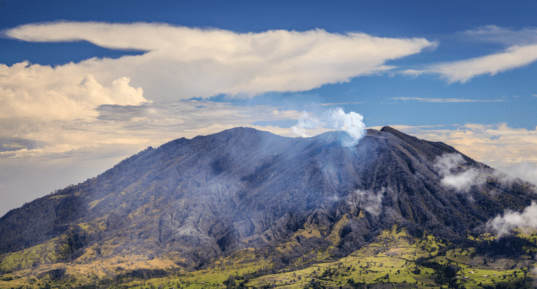
Turrialba Volcano National Park delivers the kind of volcanic experience that Poás and Arenal can’t: raw, active, still-doing-things geology that you can stand 3,281 feet (1,000 meters) from and look directly into. At 10,958 feet (3,340 meters) above sea level, this stratovolcano in Cartago province is Costa Rica’s second-tallest and its most consistently active—it has been erupting in some form since 2010 and earned the indigenous name “Tower of Fire” well before anyone was keeping records.
The one thing most travel resources don’t say upfront: you cannot hike Turrialba independently. Guided tours only, booked through ICETUR, departing between 6:00 AM and 10:00 AM. You also need a 4×4 rental vehicle for the primary Tapojo access route. Get those two logistics right before you finalize any Central Valley driving itinerary, and the rest falls into place.
Key Takeaways
- Guided tours required: $45 USD guide fee + $12 park entry paid separately at the ranger station via card
- Vehicle requirement: 4WD mandatory via Tapojo sector; La Pastora sector accommodates standard vehicles in good conditions
- Hiking distance: 2.8 miles (4.5 kilometers) round-trip, approximately 4 hours total
- Best timing: Dry season (December–April), earliest tour slot available—cloud cover closes in by mid-morning
- Tour caps: Minimum 2 people, maximum 8 per guide
- Current status: Level 2 Warning (OVSICORI scale 0–4) as of late 2025—park closes during significant volcanic events

Where Is Turrialba Volcano, and How Long Does It Take to Get There?
Turrialba Volcano sits in the eastern part of Costa Rica’s Central Volcanic Range, within Cartago province. The national park entrance is about 15 miles (24 kilometers) northwest of Turrialba city and roughly 43 miles (70 kilometers) from San José—that’s approximately 2.5 hours of driving under good conditions.
The volcano shares a geological system with neighboring Irazú Volcano National Park, Costa Rica’s tallest active volcano. Both sit along the continental divide, creating the kind of landscape where, on a clear morning, you can theoretically see the Atlantic to the east and the Pacific to the west from the summit.
Getting there requires some decision-making before you leave. The primary access route goes through the Tapojo sector via Finca Monte Calas (Route 20)—a steep, unpaved climb through dairy farms and ash-dusted agricultural land before entering the cloud forest. This route demands 4WD. The alternative is the La Pastora de Santa Cruz sector, which involves a longer approach on roads that are gentler on vehicles without full 4WD capability. La Pastora is manageable in the dry season with a standard vehicle, but can become problematic when the roads are wet. If you’re unsure which to use, booking a 4×4 vehicle eliminates the question entirely.
There’s no public transportation to the park. Your options are driving yourself or booking an ICETUR tour package that includes hotel pickup from San José or the Central Valley.
If you’re arriving at Juan Santamaría International Airport and building a Central Valley trip, Turrialba pairs naturally with Irazú, about an hour away, and Guayabo National Monument, 30 minutes from the park.
Download offline maps before you head up. Waze works well for the lower-elevation approach, but cell coverage gets unreliable once you’re climbing the mountain. The SINAC national parks system site has the current park status if you want a second source alongside OVSICORI before you leave.

Can You Actually Hike Turrialba Volcano? Here's How It Works
Yes—but with a certified guide, and that requirement isn’t bureaucratic red tape. Turrialba has had significant eruptions in 2014, 2015, 2016, and 2017, plus ongoing fumarolic activity, periodic ash emissions, and crater wall collapses that make independent hiking genuinely dangerous. The park reopened to guided visits in December 2020, and the protocols reflect hard lessons from years of active eruptions.
Tours are booked through ICETUR via their website or by emailing [email protected]. Guided tours cost $45 USD (approximately 22,500 colones), with the $12 USD park entry paid separately by credit or debit card at the ranger station. Guides monitor volcanic conditions in real-time, carry emergency equipment, and know evacuation routes. They’re also trained to recognize altitude sickness—the volcano exceeds 10,827 feet (3,300 meters), and the thin air affects visitors who underestimate elevation even if they’re fit at sea level. The Tico Times has covered Turrialba’s eruption history extensively if you want more context on the volcano’s recent activity cycle before visiting.
Tours depart hourly from 6:00 AM to 10:00 AM, with 2-person minimums and groups capped at 8 per guide. Walk-up visits are technically possible but not reliable—book ahead, especially during the dry season when spots fill.
What Does the 4-Hour Hike Actually Cover?
The 2.8-mile (4.5-kilometer) round-trip trail passes through three ecological zones as you climb. Agricultural land transitions into cloud forest, then the barren volcanic páramo near the summit—a landscape shift that makes visible exactly what Turrialba has been doing to its surroundings for decades. Ash-coated fences and crop fields on the drive up are a preview of the moonscape terrain above.
At the summit, the trail reaches Turrialba’s three craters. The westernmost crater is currently the most active, displaying consistent fumarolic venting and occasional incandescence on its inner walls. The main crater measures over 3,281 feet (1,000 meters) across and drops roughly 984 feet (300 meters) deep—a scale that only becomes real when you’re standing at the rim. The Volcanological and Seismological Observatory of Costa Rica (OVSICORI-UNA) maintains Level 2 Warning status on Turrialba through late 2025, meaning ongoing unrest with small ash emissions and crater collapses, but safe for guided visits when conditions allow. The Smithsonian Global Volcanism Program also tracks Turrialba and publishes weekly activity reports that are worth bookmarking if you’re planning a trip weeks out.
The hike itself is rated moderate. No scrambling or technical climbing required, but the altitude challenge is real—expect breathlessness at sea-level fitness levels. Guides set a pace that accommodates the group.
What Can You See on a Clear Day?
The payoff for an early start is significant. On clear mornings, panoramic views span the Central Valley, Caribbean lowlands, and the peaks of the Talamanca range. You can spot Irazú to the northwest and Barva Volcano within Braulio Carrillo National Park on the horizon. The dual-ocean view opportunity exists on the clearest days—typically February and March mornings.

When Should You Visit Turrialba Volcano?
Does Season Actually Matter at This Altitude?
At nearly 11,000 feet (3,340 meters), cloud cover is the primary enemy regardless of season—and it typically arrives by mid-morning. The single most important timing decision is booking the earliest available tour slot, either 6:00 AM or 7:00 AM.
Dry season (December–April) offers the highest probability of clear skies. February and March deliver optimal visibility with the best chance of panoramic views. This is also Costa Rica’s peak tourism season, which means more competition for tour slots—book ahead. If you’re weighing whether to visit during dry season vs. green season, Turrialba is one of the destinations where dry season genuinely matters more than most.
Rainy season (May–November) brings a vibrant green landscape and fewer visitors on the trails. Morning hours often stay dry before afternoon rains arrive, and guided tours still run when conditions allow. Cloud cover is more persistent even in morning hours, and the unpaved access roads become slicker—another reason a 4WD makes sense even outside of the Tapojo sector during these months. If you’re building a green season Costa Rica trip, morning volcano visits pair well with afternoon activities at lower elevations.
What’s the Temperature Like at the Summit?
Pack for cold regardless of when you visit. Summit temperatures average around 61°F (16°C) with significant wind chill that drops it further. Even during Costa Rica’s warmest months, the summit feels dramatically different from the Caribbean coast or Guanacaste. Layers are non-negotiable.
If you’re also visiting Braulio Carrillo or the Monteverde cloud forest on the same trip, the same cold-weather kit covers all three destinations.
What to Pack for the Turrialba Hike
Footwear: Sturdy hiking boots with ankle support and aggressive tread. Loose volcanic rock and morning dew make surfaces slick. Trail runners are marginal; sandals are dangerous.
Layers:
- Moisture-wicking base layer (the trailhead feels warmer than the summit)
- Insulating mid-layer—fleece or light down
- Waterproof/windproof outer shell
- Long pants for wind and volcanic rock protection
Other essentials:
- At least 34 ounces (1 liter) of water per person—exertion at altitude depletes you faster than you expect
- Snacks for the trail
- Sunscreen, sunglasses, and a hat—UV intensity increases dramatically at this elevation, even on cloudy mornings
- A camera with good zoom for crater detail
- A bandana or light buff for sulfur gas near active vents—guides will direct you, but having it on hand is smart.
The base station has restrooms, a small café run by a local family, and WiFi. A second basic restroom sits about 0.6 miles (1 kilometer) from the summit near the ranger station. Plan to be self-sufficient on the trail itself. The Costa Rica Tourism Institute (ICT) lists Turrialba under active volcano experiences if you want official trip-planning context from the national tourism board—though ICETUR is your actual booking contact.

How Do You Get to Turrialba Volcano National Park?
Driving from San José
From San José, head east on Route 2 toward Cartago, then follow signs toward Turrialba. Before reaching Turrialba city, turn north toward Pacayas and the volcano. Total drive time is approximately 2.5 hours in good conditions. From Cartago city, allow about 1.5 hours.
Tapojo Sector (4WD required): Direct approach through agricultural zones. Steep, unpaved final stretch with significant grades and loose surfaces. This is the most common route for visitors with appropriate vehicles.
La Pastora Sector (standard vehicle possible in dry season): Longer route with easier road demands. Conditions vary seasonally—the rainy season makes even this sector more challenging without 4WD.
Which Vehicle Do You Actually Need?
For the Tapojo route: a 4×4 is non-negotiable. For La Pastora in the dry season, a capable standard SUV can manage. For anyone visiting May through November: book a 4WD and don’t second-guess it. The vehicle decision for Costa Rica’s mountain routes typically comes down to whether you want access flexibility or just getting from point A to point B, and Turrialba’s roads reward the vehicle with clearance.
If you’re flying into SJO and building a broader volcano itinerary, arranging the right vehicle from the airport simplifies everything. The SJO road trip routes guide has a full breakdown of which Central Valley destinations need what vehicle class.
What Else Can You Do in the Turrialba Region?
The guided hike typically finishes by early afternoon, leaving time for more. The Turrialba area rewards an overnight stay or multi-day visit.
What Are the Best Same-Day Combinations?
Guayabo National Monument: Costa Rica’s most significant pre-Columbian archaeological site sits about 30 minutes from Turrialba city. The ancient settlement features stone roads, functional aqueducts, and petroglyphs from civilizations that flourished between 1000 BC and 1400 AD. After volcanic terrain, the forested archaeological site is a different kind of impressive.
Irazú Volcano National Park: Irazú is about an hour from Turrialba. At 11,260 feet (3,432 meters), it’s Costa Rica’s tallest active volcano—with a paved road, no guide requirement, and a famous turquoise crater lake. Combining both in one day works if you start early and keep moving. The Poás vs. Irazú comparison covers the logistics in detail for anyone building a volcano day-trip.
CATIE Botanical Gardens: The Tropical Agricultural Research and Higher Education Center runs guided tours through extensive botanical collections near Turrialba city. A gentler afternoon option after a morning summit hike, and a nice complement for travelers who checked off Costa Rica’s top activities and want something off the beaten path.
Is Turrialba Worth a Multi-Day Stay?
For adventure-focused travelers, yes. The Pacuare River runs through remote rainforest accessible from Turrialba and consistently ranks among the world’s best whitewater rafting destinations. Full-day Class III-IV rafting trips pair well with a volcano morning. The Lonely Planet Costa Rica guide also highlights the Pacuare as one of the country’s top adventure experiences alongside the Turrialba volcano area.
The Turrialba region also produces distinctive highland coffee and the namesake Turrialba cheese—a white, semi-soft protected denomination of origin product. Farm tours around the area cover both, giving an agrotourism angle that balances the adventure activities.
From Turrialba, you can continue northeast toward the Caribbean coast via Siquirres, or return through Cartago with stops in the Orosi Valley. It works as a dedicated destination or as a waypoint in a broader 2-week Costa Rica itinerary.
For first-time visitors, Turrialba fits naturally into a 1-week itinerary as a Central Valley day before heading to Arenal or the coast.

Where Should You Stay Near Turrialba Volcano?
Guayabo Lodge (4.5/5, TripAdvisor) sits on the volcano’s slopes at 4,921 feet (1,500 meters) elevation, with direct views of the crater from the property. The eco-lodge runs guided volcano tours for guests, and the restaurant serves a changing menu built around tropical ingredients and the lodge’s own cooking school. Rates typically run $90–$150/night, including breakfast. Book ahead during dry season—it’s popular with birders year-round. Details at guayabolodge.co.cr.
In Turrialba city, Several comfortable hotels give you town amenities, restaurant access, and a shorter drive to both Guayabo National Monument and the volcano. The city is about 30 minutes from the park area and serves as a convenient base if you’re combining multiple Turrialba region activities.
Whatever you choose, book early for December through March. Accommodation near the volcano is limited, and the best properties fill up when weather conditions favor clear summit views.

Turrialba is the volcano you visit when you want to feel like the geology is still happening rather than just looking at the aftermath. It asks more of you than Irazú’s easy paved road or Arenal’s tamed cone—but the tradeoff is standing at the rim of something genuinely active, with fumaroles venting and fresh volcanic deposits underfoot. A 4WD rental from Vamos gives you the flexibility to pair it with Guayabo, Irazú, and onward to the Caribbean coast without being locked into a tour schedule.
Frequently Asked Questions
How far in advance do you need to book the Turrialba guided tour?
Booking 1–2 weeks ahead is sufficient for rainy season visits. During dry season (December–April), especially February and March, slots fill faster—aim for 2–3 weeks minimum. Contact ICETUR via icetur.com or [email protected] to confirm availability and reserve. Walk-ups occasionally work but aren’t reliable enough to plan around.
What’s the difference between the Tapojo and La Pastora access routes?
Tapojo is the direct, shorter route requiring 4WD due to steep, unpaved roads—this is what most visitors use. La Pastora adds distance, but the roads are gentler and manageable for standard vehicles during the dry season. If you’re visiting May through November or after heavy rain, La Pastora still benefits from 4WD. When in doubt about conditions, the ICETUR team can advise when you make your reservation.
Can you visit Turrialba Volcano if the park is closed due to activity?
No—when OVSICORI raises the alert level above current thresholds, SINAC closes the park, and tours don’t run. This isn’t theoretical; it happened repeatedly between 2014 and 2020. Always confirm park status via OVSICORI’s website (ovsicori.una.ac.cr) or by contacting ICETUR directly within a few days of your visit, especially if any news about volcanic activity has come up. The park’s closure history is why same-day confirmation matters more here than at other Costa Rica national parks.
Is Turrialba harder to hike than other Costa Rica volcanoes?
Technically, no—the trail doesn’t involve scrambling, and Irazú’s paved walkway is easier in practical terms. What makes Turrialba harder is the altitude. At 10,958 feet (3,340 meters), even fit sea-level hikers feel the thin air. Many visitors who’ve done the Arenal trails or Monteverde suspension bridges without any trouble find Turrialba more physically demanding simply because of the elevation. Pace yourself, drink water before you’re thirsty, and let your guide set the tempo.
What’s the best volcano to visit in Costa Rica if you want to see actual activity?
If you want visible volcanic processes rather than scenic cones, Turrialba delivers things the others currently don’t: fumaroles actively venting, fresh volcanic deposits, and occasional incandescence in the crater at close range. Poás has the turquoise acid lake and good visitor infrastructure. Irazú has scale and elevation. Arenal has the iconic shape and hot springs. But for raw geological activity visible from the rim, Turrialba is in a category of its own right now—which is exactly why the guide requirement exists.
Do you need travel insurance for Turrialba Volcano?
Standard travel insurance is always worth having in Costa Rica, regardless of where you’re going. For Turrialba specifically, the volcanic activity risk makes it worth reading your policy’s adventure activity and natural hazard clauses. Most comprehensive policies cover guided hiking at active volcanoes, but confirming beforehand is faster than finding out afterward.
Is Turrialba suitable for kids?
It depends on the child. The altitude (over 10,827 feet / 3,300 meters) is the main limiting factor—children who haven’t been at elevation before can experience altitude sickness symptoms more quickly than adults. The hike itself isn’t technically demanding. ICETUR guides can advise on age and fitness suitability when you book, and most families with older children (10+) who are comfortable hiking find it manageable. Young children and those with respiratory conditions should consult with a doctor before attempting high-altitude hikes in Costa Rica. For Costa Rica family travel with younger kids, Irazú or Poás are more accessible alternatives to Turrialba, given their shorter walks and lower altitude demands.