
Last Updated on June 19, 2026
Los Quetzales National Park: What's Covered
Los Quetzales National Park sits 2 hours south of San José on Route 2, protecting 12,355 acres of cloud forest at 6,600–9,800 feet elevation. Entry is $10 USD for adults — pre-booked online through SINAC before arrival, as no walk-up sales exist and there’s no cell service at the entrance. Peak quetzal season runs late January through April. A standard rental car handles Route 2 fine — no 4×4 needed.
Quick Facts:
- Entry: $10 USD adults, $5 USD children — online pre-booking mandatory since May 2025
- Location: 47 miles (76 km) south of San José on Route 2, near San Gerardo de Dota
- Elevation: 6,600–9,800 ft (2,000–3,000 m) — pack warm layers; temperatures 53–62°F (12–17°C)
- Trails: Zeldonia Trail (1,312 ft / 400 m, paved, 30 min) and Ojo de Agua Trail (1.25 miles / 2 km, dirt, 2 hours)
- Best quetzal viewing: Late January–April; peak sightings along the San Gerardo de Dota valley road
Top 4 Tips for Los Quetzales:
- Download your ticket — No cell signal at the entrance; save your SINAC confirmation offline before you leave coverage.
- Target the valley too — The San Gerardo de Dota road often produces better quetzal sightings than the park trails; combine both for the full experience.
- Book a lodge guide — Local guides from Savegre Hotel or Trogon Lodge know which trees quetzals are using that morning.
- Use it as a route stopover — Los Quetzales sits perfectly on Route 2 between San José and the southern Pacific coast.
If you need any help with a Costa Rica car rental, contact us now!
Los Quetzales National Park sits along Route 2 in the Talamanca highlands, 2 hours south of San José. At 6,600–9,800 feet (2,000–3,000 meters) elevation, it protects 12,355 acres of cloud forest — and unlike Monteverde, you’ll likely have the trails to yourself.
Key Takeaways
- Tickets must be purchased online through SINAC’s reservation system before you arrive — there’s no cell service at the entrance and no walk-up sales as of May 2025.
- Entry costs $10 USD for adults and $5 USD for children ages 6–12, with two short trails: a paved 1,312-foot (400-meter) loop and a 1.25-mile (2 km) dirt path.
- The best quetzal sightings typically happen along the main road through San Gerardo de Dota — not necessarily inside the park itself.
- Late January through April is peak quetzal season, with March and April being the absolute sweet spot.
- A standard sedan handles Route 2 just fine — no 4×4 required to reach the park entrance.

Where Is Los Quetzales National Park?
Los Quetzales National Park sits in the Dota canton of San José Province, about 47 miles (76 kilometers) south of the capital on Route 2 — the Pan-American Highway. The park protects a critical stretch of highland forest along the upper Savegre River basin, and the nearest settlement is San Gerardo de Dota, a small mountain village that has quietly become one of Costa Rica’s top birdwatching destinations.
The region sits within what locals call the Cerro de la Muerte — literally “Mountain of Death,” a name earned by the historically difficult conditions travelers faced crossing these highlands before paved roads existed. Today, Route 2 is fully paved, well-maintained, and one of the most scenic highland drives in the country.
How Do You Get There from San José?
The drive takes about 2 hours via Route 2 heading south through Cartago. If you have extra time, a detour to Irazú Volcano before hitting the highway south makes a solid first-day combination from SJO. The park entrance sits directly off Route 2 — look for “Parque Nacional Los Quetzales” on Waze or Google Maps, or use “Los Chesperitos 1” (the restaurant across the highway from the entrance) as your landmark.
One critical heads-up: there’s no cell service at the park entrance, which matters a lot now that tickets are online-only. Purchase through SINAC’s reservation portal before you leave wherever you’re staying, and download your confirmation so it’s accessible offline.
Do You Need a 4×4 to Get Here?
No. The park entrance sits directly off the main highway with no unpaved access required — a standard sedan handles Route 2 just fine. If you’re planning to stay in San Gerardo de Dota itself, some lodges in the valley require descending a steep paved road off Route 2, where higher clearance is useful but not essential during the dry season. Understanding driving conditions in Costa Rica before a highland trip like this is always worth a few minutes of reading.
What Actually Makes This Cloud Forest Worth Visiting?
Cloud forests cover less than 1% of the global forest and form only where mountains intercept moisture-laden air, creating permanent mist and a strikingly unusual ecosystem. Giant oaks wrapped in mosses, bromeliads, and ferns replace the tall-canopy trees of lowland rainforests. Los Quetzales protects one of Central America’s finest examples of this habitat at elevations where species that don’t exist anywhere else in Costa Rica quietly go about their lives.
This isn’t the same Costa Rica as Braulio Carrillo or the Pacific beaches near Manuel Antonio. It’s cooler, mistier, quieter, and built around a completely different cast of wildlife — which is exactly the point for travelers who’ve already done the classic circuit.
What Wildlife Can You See Here?
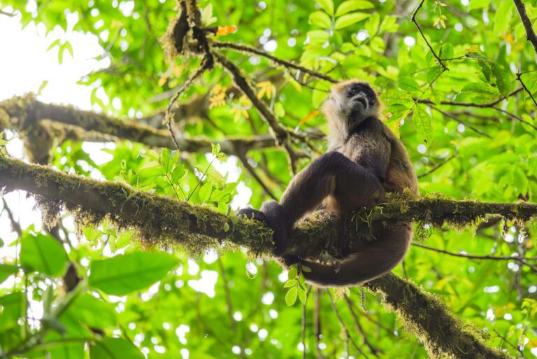
The Resplendent Quetzal gets top billing. The Resplendent Quetzal carries iridescent green plumage and flowing tail feathers reaching up to 26 inches (65 centimeters) long — and during breeding season, males are genuinely one of the most striking birds in the Western Hemisphere. The park also supports over 200 bird species, including trogons, hummingbirds, tanagers, and the Sooty Robin. Mammal residents include Baird’s Tapir (Central America’s largest land mammal), white-faced capuchin monkeys, coyotes, and pumas.
The Resplendent Quetzal is Near Threatened on the IUCN Red List, primarily due to habitat loss and climate-related shifts in cloud forest distribution. Los Quetzales and the surrounding Dota canton represent some of the birds’ most critical remaining habitat in Costa Rica. If quetzal watching is on your Costa Rica activities list, this is one of the most legitimate places in the country to check it off.
Is the National Park Itself the Main Attraction?
Here’s the honest take: not entirely. The park has two short trails and no dramatic endpoints — no waterfalls, no sweeping viewpoints, no hanging bridges. The real magic of this region runs across the entire Dota canton, particularly along the main road through San Gerardo de Dota, where quetzals feed in aguacatillo (wild avocado) trees during nesting season and are visible from the roadside. Most guided quetzal tours don’t even enter the national park — they work the valley road and private lodge trail networks where encounter rates are higher.
The park is absolutely worth visiting for cloud forest immersion, especially if you’re passing through on Route 2. But if quetzal sightings are your primary goal, pairing the park with a guided lodge tour gives you significantly better odds than hiking solo.

What Are the Trails Like?
The park has two marked trails currently open, both linear — you hike in and turn around when you reach the end. Details are confirmed through the official SINAC page for Los Quetzales.
What Should You Expect on the Zeldonia Trail?
The Zeldonia Trail (sometimes listed as the Circular Trail) covers about 1,312 feet (400 meters) and takes around 30 minutes round-trip. It’s paved with concrete and has metal staircases, making it the more accessible option for most fitness levels. Rangers tend to recommend this shorter trail as the better choice for birdwatching — the firm surface lets you move quietly and focus on the canopy rather than navigating your footing.
How Difficult Is the Ojo de Agua Trail?
The Ojo de Agua Trail extends about 1.25 miles (2 kilometers) into secondary forest and takes around 2 hours round-trip. It’s entirely unpaved, descends on the way in, and climbs back out — so the return is considerably harder than the approach. The rainy season turns sections into a mud challenge; the dry season is significantly more enjoyable. You’ll find the trailhead by walking left from the main ranger station for about 5 minutes. The further you get from the highway, the quieter and more immersive the forest becomes.
At up to 9,800 feet (3,000 meters), expect the thinner air to register. Even fit hikers notice increased breathing effort on the Ojo de Agua return climb — altitude matters, so pace yourself and bring more water than you think you’ll need. This is a very different experience from hiking at sea-level parks like Carara or the easier terrain around Poás Volcano.

What's the Deal with Seeing Quetzals?
When Is the Best Time to Spot Quetzals?
Late January through April is quetzal season in the Dota region. This is nesting period — males display for females, both parents make frequent feeding trips to aguacatillo trees, and the birds concentrate their activity near reliable food sources. March and April are the absolute peak of breeding activity, with early morning visits (as close to the 7:30 AM opening as possible) giving you the best conditions before cloud cover builds. Outside of breeding season, quetzals are present year-round but far more difficult to locate.
If you’re specifically chasing quetzals across Costa Rica, the Curi Cancha Reserve in Monteverde and the Santa Elena Cloud Forest Reserve are the other top-tier options. San Gerardo de Dota and Los Quetzales consistently rank among the best quetzal destinations in the country, particularly during the Jan–April window.
For a deeper dive into what makes this region so productive for bird life, the Monteverde Cloud Forest Biological Reserve provides a useful comparison ecosystem — and our Costa Rica birdwatching guide covers where each species is most reliably spotted across the country.
Does Hiring a Guide Actually Make a Difference?
Significantly, yes. Quetzals are surprisingly cryptic despite their vivid colors — they blend into the canopy in ways that confuse even experienced wildlife viewers. Local guides know which specific trees the birds have been feeding in that morning, understand their daily movement patterns, and carry spotting scopes that let you see birds at 50+ meters clearly.
The Savegre Hotel maintains its own private trail network that non-guests can book into. Trogon Lodge offers similar guided experiences. Both properties have guides with up-to-the-minute knowledge of where the quetzals are. That kind of local intelligence is simply unavailable on a self-guided national park visit. If a quetzal sighting is the reason you’re making this trip, book a guided tour through one of these lodges — don’t rely solely on the park trails. The national park doesn’t station guides at the entrance, so arrange this in advance.
What Does It Cost to Visit?
Entry for adult foreigners is $10 USD, and $5 USD for children ages 6–12. As of May 2025, all tickets must be pre-purchased through SINAC’s online reservation system — no walk-ups. Download your confirmation before leaving cell service range, because you’ll need it,t and there’s no signal at the entrance.
Parking is free with a decent-sized lot at the ranger station. The restaurant across the highway — Los Chesperitos 1 — serves coffee, hot chocolate, and meals. Given the 53–62°F (12–17°C) temperatures, warming up before a trail is genuinely welcome. You’ll appreciate having Costa Rica currency sorted in advance — the restaurant accepts cash, and some rural spots between San José and here are cash-preferred.
Compared to other budget-friendly Costa Rica national parks, the $10 entryfee is reasonable. Honest reviewers note the short trails make this feel different from parks like Manuel Antonio or Braulio Carrillo, where you can spend a full day hiking. The real value proposition here is the broader Dota region, not just the park itself.

Is San Gerardo de Dota Worth More Than a Quick Stop?
Absolutely — and this is the part most drive-by visitors miss. The valley of San Gerardo de Dota sits about 30 minutes below Route 2 along a steep paved descent, and it’s one of Costa Rica’s most genuinely rewarding off-the-circuit destinations. The Savegre River flows through the center of the valley and is widely cited as one of the cleanest waterways in Central America. Trout fishing, waterfall hikes accessible via AllTrails, and quetzal-lined morning walks along the main road make this place worth an overnight stay, not just a rushed two-hour stop.
What Else Is Worth Doing in the Area?
The Tarrazú coffee region sits nearby and produces some of Costa Rica’s most prestigious high-altitude arabica. Pairing a Los Quetzales visit with a coffee farm tour creates a genuinely full highland day — the beans grown at 5,000–6,500 feet carry flavors that flat-grown coffee simply can’t replicate. If Lonely Planet’s coverage of Costa Rica’s coffee region is any guide, the Dota area is increasingly recognized as a destination in its own right.
The private trail networks at lodges like Savegre Hotel and Trogon Lodge are also worth exploring beyond just guided quetzal tours. The forest the lodges protect is high quality, and you’re often walking through terrain the quetzals actively use.
How Does Los Quetzales Connect to Bigger Costa Rica Trips?
This park sits at the ideal midpoint for anyone driving between San José and the southern Pacific coast. Continuing south on Route 2 puts you in San Isidro del General in about an hour — the gateway to Chirripó National Park and eventually the Osa Peninsula, including Caño Island snorkeling and Corcovado.
Heading north, you’re back toward the Central Valley, connected to the Caribbean via Braulio Carrillo or westward toward the Pacific coast and Arenal via scenic routes through the highlands. Either direction, Los Quetzales sits on the route — not off it.
For travelers building two-week Costa Rica itineraries or one-week routes that include the southern zone, Los Quetzales makes a natural 2–3 hour stop that adds an entirely different ecosystem without requiring a detour. You’re on the route already — the park comes to you.

What Should You Pack for Los Quetzales?
At 53–62°F (12–17°C) with constant mist, this isn’t beach gear territory. Bring long pants, a warm fleece or midlayer, and a waterproof rain shell — mist and light rain are constant possibilities regardless of season. Closed-toe hiking shoes with traction are essential; the Ojo de Agua trail gets muddy, and concrete stairs on Zeldonia can be slippery when wet. Gloves for early morning visits are worth tossing in a day pack.
For birdwatching, binoculars are not optional. You will not spot quetzals at 40+ meters in the canopy without them. A camera with at least a 300mm telephoto lens lets you photograph what binoculars reveal. Insect repellent helps on the Ojo de Agua trail, though mosquitoes are far less prevalent here than in lowland parks like Tortuguero or Palo Verde.
Los Quetzales rewards a little preparation — download your SINAC ticket, verify your hiking footwear has grip, and bring more layers than you think you’ll need. That’s basically the whole checklist. Travelers heading to the Costa Rica airport afterward will want to factor in the 2-hour drive back to San José when timing a return flight. For visitors combining this with Barra Honda caves in Guanacaste or other parks on a longer loop, this highland stop adds an ecosystem comparison that’s hard to replicate elsewhere.

Frequently Asked Questions
Do You Need to Book Tickets in Advance?
Yes — as of May 2025, this is mandatory, not optional. All tickets must be purchased through SINAC’s online reservation system before you arrive at the park. Since there’s no cell service at the entrance, your confirmation needs to be downloaded offline beforehand. The park rarely fills to capacity the way Manuel Antonio does, so availability isn’t usually a problem, but the pre-booking rule applies regardless.
What Is the Difference Between Los Quetzales National Park and San Gerardo de Dota?
Los Quetzales National Park is the SINAC-managed protected area accessed via the Route 2 highway entrance. San Gerardo de Dota is a mountain village and valley located about 30 minutes below Route 2 within the broader park corridor. Most guided quetzal tours, private lodge networks, and the most productive quetzal viewing spots are in the valley — not at the national park entrance itself. They’re two parts of the same destination, with the valley generally delivering the richer experience for most visitors.
Why Is the Resplendent Quetzal Considered So Significant?
The quetzal held sacred status for Maya and Aztec civilizations, who used its iridescent tail feathers in royal headdresses. It remains Guatemala’s national bird and appears on its currency and banknotes. In Costa Rica, the quetzal’s dependence on cloud forest ecosystems tied its survival directly to highland conservation, which is part of why Los Quetzales became Costa Rica’s 28th national park in 2006. Habitat loss, deforestation, and climate shifts affecting cloud forest distribution are the primary modern threats to the species.
Is Los Quetzales Worth Visiting If You’re Not a Birder?
Honestly, the national park alone might feel underwhelming if cloud forest ecology or birdwatching aren’t your focus — the trails are short and don’t end at dramatic landmarks. But the broader region offers real appeal: San Gerardo de Dota’s mountain valley atmosphere, the Savegre River, Tarrazú coffee country, and the unusual experience of a Costa Rica that runs 55°F instead of 85°F. If you’re driving Route 2 south anyway, a stop makes easy sense even without binoculars.
How Does the Weather at Los Quetzales Differ from the Rest of Costa Rica?
The park sits at 6,600–9,800 feet (2,000–3,000 meters), which places it in a distinct climatic zone. Temperatures run 53–62°F (12–17°C) year-round, fog and mist are constant, and the “dry season” here is relative — cloud forests stay damp because that’s what defines them. What this means practically: you can visit during Costa Rica’s rainy season (May–November) and still experience a beautiful forest without heavy rain, though trails will be muddier than December–April conditions.
What Are the Opening Hours for Los Quetzales National Park?
The park opens at 7:30 AM and closes at 3:30 PM daily. Arriving as close to opening as possible gives you the best wildlife conditions — quetzals and other birds are most active in the first 2–3 hours of light, before cloud cover builds and temperatures warm slightly. There is no night access.
How Long Does a Visit to Los Quetzales Typically Take?
Most visitors spend 2–3 hours at the national park itself. If you hike both the Zeldonia Trail (30 minutes) and Ojo de Agua Trail (2 hours round-trip), you’ve covered the main offerings. Adding time for the restaurant across the highway and a slow drive through San Gerardo de Dota valley brings a full visit to about 4–5 hours. Those staying overnight in the valley can combine the park with a guided early morning quetzal tour for a genuinely comprehensive highland experience.